Saturday, January 27, 2018
Marston Trussell and Sibbertoft, just missing Clipston
Thursday 25 January, at 10am. With Maureen. 8 Miles.
Another brilliantly sunny, blue-skied day, with a noticeable wind. Warm enough when we were moving. We chose to walk along the quiet roads in this area rather than take to the footpaths over mud-sodden fields. The walk was very similar to one we did on March 6th 2014, but in reverse and missing out the mile-long detour into Clipston village.
We turn left from the church and walk through Marston Trussell village, turning right with the main road, toward Clipston. It takes us past the lake, and at the junction toward Sibbertoft we turn right, following the road gradually uphill.
 At the top is the ROC viewpoint:
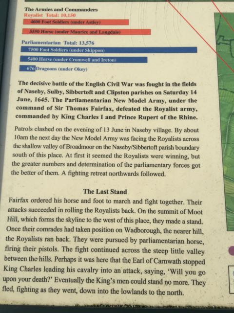
The info below comes from The Naseby Battlefield Project's website:
From the Royal Observer Corps lookout the full sweep of the day’s battle can be appreciated. To the north-east Rupert’s Viewpoint can be seen near East Farndon. Turning clockwise, the communications mast next to the A14 stands on the skyline and further right Fairfax’s Viewpoint. The spire of Naseby Church projects from behind a clump of trees and then the white bulk Mill Hill Farm appears. Woods obscure a view of Broadmoor, but then Lowe Farm, opposite the Reservoir parking, shows and to the right of that a lone tree stands on Moot Hill with the woods to the right of the open field.
The stand on that hill continued until their comrades had established themselves on the nearer hill, Wadborough. Then the defenders of Moot Hill turned and ran for their lives, down the slope into the valley and up to their new position to continue the fight. How long they held out on Wadborough is impossible to say, but eventually they could stand no more and they fled down the slope to the right, still turning and resisting from time to time. The lucky ones, mostly horse, made it to Leicester.


 After our short detour to visit the viewpoint, we were confronted by a different sort of army, just before Sibbertoft.
 In Sibbertoft I saw my first snowdrops in full bllom for this year.
 The bench in the churchyard was in a sheltered and sunny spot. As we had our snack, a friendly woman told us that they are trying to encourage flowers to grow around the village, and to avoid mowing too frequently. All good for the insects, bees and birds.
The source of the Welland claims to be in the Hothorpe Hills, close to the 540-foot (160 m) contour near Welland Rise, Sibbertoft.
We took the road past the church , decided against the muddy field paths and followed it downhill, taking the left hand fork towards Marston Trussell and Theddingworth.
 Almost opposite Hothorpe Hall, we turned right and arrived back at Marston Trussell.


Another brilliantly sunny, blue-skied day, with a noticeable wind. Warm enough when we were moving. We chose to walk along the quiet roads in this area rather than take to the footpaths over mud-sodden fields. The walk was very similar to one we did on March 6th 2014, but in reverse and missing out the mile-long detour into Clipston village.
We turn left from the church and walk through Marston Trussell village, turning right with the main road, toward Clipston. It takes us past the lake, and at the junction toward Sibbertoft we turn right, following the road gradually uphill.

The info below comes from The Naseby Battlefield Project's website:
From the Royal Observer Corps lookout the full sweep of the day’s battle can be appreciated. To the north-east Rupert’s Viewpoint can be seen near East Farndon. Turning clockwise, the communications mast next to the A14 stands on the skyline and further right Fairfax’s Viewpoint. The spire of Naseby Church projects from behind a clump of trees and then the white bulk Mill Hill Farm appears. Woods obscure a view of Broadmoor, but then Lowe Farm, opposite the Reservoir parking, shows and to the right of that a lone tree stands on Moot Hill with the woods to the right of the open field.
The stand on that hill continued until their comrades had established themselves on the nearer hill, Wadborough. Then the defenders of Moot Hill turned and ran for their lives, down the slope into the valley and up to their new position to continue the fight. How long they held out on Wadborough is impossible to say, but eventually they could stand no more and they fled down the slope to the right, still turning and resisting from time to time. The lucky ones, mostly horse, made it to Leicester.




 |
| St Helen's, Sibbertoft |
We took the road past the church , decided against the muddy field paths and followed it downhill, taking the left hand fork towards Marston Trussell and Theddingworth.
 |
| We didn't see any of these! |

 |
| Marston Trussell church (St Nicholas) |

 |
| More snowdrops |


