Wednesday, 20 January 2021

Intro

 In 2014, Marta and I decided to explore the Welland. We didn’t do it very logically, and the early course between Sibbertoft and Marston Trussell seems to be mostly on private land. We have driven along some of the roads and taken photos at the bridges, but haven’t posted them yet. The other posts need editing and ordering, to make some kind of narrative. 

I’ve copied them from my main walking blog aliwalks

The posts here include various walks taking in part of the Welland, and some are the same walk in different weather. 

More photos near Gretton Weir in 2015

Saturday, August 15, 2015

Seven cygnets swimming

An unusually large brood, seven cygnets, now the size of their parents.  They arrived in orderly fashion, in single file, with one parent ahead and one behind . . .


 In turn they looked up as the camera clicked when they emerged from under the bridge . . .
 Papa stretched his wings .
 All found plenty of weed to feed on in the old mill pool . 


Finally they left in convoy as they arrived.

The swans have been luckier than the dead sheep lying at the bottom of the weir, bloated and with legs in the air.


Cycling near Boston. Fosdyke Bridge


Friday, November 27, 2020

Cycling near Boston - Oct 24 - 15 windy miles.

 We escaped for a self-catering weekend - rearranged from earlier in the year when we had hoped to see a show at Blackfriars Theatre. 

Instead we took the bikes and explored a part of the Fens north of where the Welland merges into the Wash. 

I had walked on the southern side five years ago  . 


We cycled from Kirton to Frampton church and along small roads, some of which were part of National Cycle Network Route 1. 


The elevation profile might lead you to think this was an easy ride, but you should never discount the wind in the Fens. All the way to Fosdyke Bridge it was hard work and we were more than ready to stop for a break.

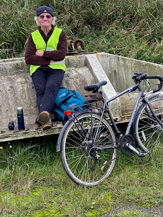
The cafe I visited in 2015 was closed, but as always we had our trusty flask.  Not the most scenic place to stop,  but at least we were sheltered from the gale.

"Be bright, be seen!"


The Welland, looking inland


and out towards the sea


The ride from this point on was much easier wind assisted all the way. 


The view from the apartment

Gretton, Rockingham, Caldecott in wintry weather


Sunday, February 3, 2019

Gretton, Rockingham, Great Easton, Caldecott, Gretton

Thursday 31 January 2019.  9.5 miles with Harry and Eddie on a very cold frosty morning, with mist in the valley, then glorious sun. We  followed the path to the end of Huntsfield Drive, then continued through the ginnel, jitty, alley way and picked up the path alongside the hedge. When we reached the track at the end we turned right. This took us to Corby Road. We turned right to walk a short distance along the road verge, before taking the track on the left hand side. 
When we reached a gate and some woodland we turned right, with a hedge on our left and followed the path.  Today the fields were white and frozen, with a smattering of overnight snow.

 As we reached the highest point, the valley was hidden in mist - magical.


A floating pylon

We walked along the mini escarpment and then downhill to cross the railway line. The path continues in this direction. Look out for a gate over on the right as you come through a hedge. At this crossing of paths, we turned left, in the direction of Rockingham, along the route of the Jurassic Way. There are one or two places where the path is not clear.  And we still haven't worked every step out...
Onward to Rockingham
We turnright down Rockingham hill, and cross the road. We make our way to the tea-shop just after the Sondes Arms for a welcome coffee and snack, at about 4 miles into the walk. We've warmed up and don't need to sit too close to the fire!
We continue along the Jurassic Way, which goes over a field and crosses the Rockingham_ Cottingham Road, heading on northwest towards the Welland.  The mist has lifted by now.


 There is ice by the river
...and some fine reflections.

The Jurassic Way path continues as far as the road from Great Easton to Caldecott. At the road, it turns left, but we went right away from the village nad towards Caldecott. There's a bit of road walking here, where we had to keep hopping up on to the grass verge.At the A6003 we turn left and walk into Caldecott, turning right when the road bends round to the left. A couple of hundred yards past the houses our footpath is signed, and we head northeast, eventually arriving at the river, after a few fields.  

We take the path just after the river, and head uphill toward the railway line. Once that is crossed it's another uphill drag to Church Gap.

But waht a beautiful day for a walk.


Thursday, March 28, 2019

Harringworth - Barrowden - Morcott - Seaton round

Thursday 28th March, with Maureen and Eddie. The same walk as last Thursday, but in reverse. About 8.5 miles. Fine and warm once more.

From Harringworth village centre we walked a short distance along the road to Wakerley, then turned left to the path through the field near the stables. We followed it to the Welland, and walked with the river on our left as far as Turtle Bridge.
Here we crossed the river and continued our walk along the field edges before heading diagonally to the left, and slightly uphill into Barrowden, through a field of sheep and lambs.
We followed Back Lane and eventually reached King Street and the Commnity Shop and cafe. Almost 3 miles, so it was an early break for coffee.
Out of Barrowden via the village green and duckpond.
Vantage point for a photograph

There was an uphill stretch along the road towards the windmill, just before the A47, which is easier to cross from this side of the road!


Through a short woodland section with plenty of violets underfoot, then across a recently ploughed but smooth and dry field.
Down a flight of steps, and across the A6121 and through part of Morcott village, until we met the waymarker indicating our footpath, along Mount Pleasant Road. This soon leads into a field. It goes slightly uphill and before too long back to the A47, close to the petrol station complex. We crossed and took the path directly in front us. Another ploughed field, but again dry and smooth, and going downhill, with good views around. 
At the bottom of this slope we turned right and followed the yellow posts as far as the railway bridge. Under this and we turned left then right for a short steep climb up to the road to Seaton.
In Seaton we paused for a rapid drink, sitting in the sun outside the George and Dragon.
Seaton Church
Our route took us down church Lane and past a few houses, then downhill with views of the viaduct, across a disused railway line and across the minor road. Through a small gate and along the drive of the very impressive farmhouse. The path goes round the house, and over a wooden footbridge, before heading across fields towards the Welland, and over the river, then left under the viaduct and back into Harringworth, via the churchyard.

Harringworth church.

Lots of daffodilas and spring flowers in the villages. Celandines, violets, primroses and blackthorn in abundance.
Tortoiseshell and brimstone butterflies.
Lunch at Lydia's cafe, Gretton.


Marston Trussell and Sibbertoft


Saturday, January 27, 2018

Marston Trussell and Sibbertoft, just missing Clipston

Thursday 25 January, at 10am. With Maureen. 8 Miles.  

Another brilliantly sunny, blue-skied day, with a noticeable wind. Warm enough when we were moving.  We chose to walk along the quiet roads in this area rather than take to the footpaths over mud-sodden fields. The walk was very similar to one we did on March 6th 2014, but in reverse and missing out the mile-long detour into Clipston village.

We turn left from the church and walk through Marston Trussell village, turning right with the main road, toward Clipston. It takes us past the lake, and at the junction toward Sibbertoft we turn right, following the road gradually uphill.


At the top is the ROC viewpoint: 
The info below comes from The Naseby Battlefield Project's website:
From the Royal Observer Corps lookout the full sweep of the day’s battle can be appreciated. To the north-east Rupert’s Viewpoint can be seen near East Farndon. Turning clockwise, the communications mast next to the A14 stands on the skyline and further right Fairfax’s Viewpoint. The spire of Naseby Church projects from behind a clump of trees and then the white bulk Mill Hill Farm appears. Woods obscure a view of Broadmoor, but then Lowe Farm, opposite the Reservoir parking, shows and to the right of that a lone tree stands on Moot Hill with the woods to the right of the open field. 

The stand on that hill continued until their comrades had established themselves on the nearer hill, Wadborough. Then the defenders of Moot Hill turned and ran for their lives, down the slope into the valley and up to their new position to continue the fight. How long they held out on Wadborough is impossible to say, but eventually they could stand no more and they fled down the slope to the right, still turning and resisting from time to time. The lucky ones, mostly horse, made it to Leicester.


After our short detour to visit the viewpoint, we were confronted by a different sort of army, just before Sibbertoft.
In Sibbertoft I saw my first snowdrops in full bllom for this year.
The bench in the churchyard was in a sheltered and sunny spot. As we had our snack, a friendly woman told us that they are trying to encourage flowers to grow around the village, and to avoid mowing too frequently. All good for the insects, bees and birds.
St Helen's, Sibbertoft
The source of the Welland claims to be in the Hothorpe Hills, close to the 540-foot (160 m) contour  near Welland Rise, Sibbertoft.
We took the road past the church , decided against the muddy field paths and followed it downhill, taking the left hand fork towards Marston Trussell and Theddingworth.


We didn't see any of these!
Almost opposite Hothorpe Hall, we turned right and arrived back at Marston Trussell.
Marston Trussell church (St Nicholas)


More snowdrops


Intro

 In 2014, Marta and  I decided to explore the Welland. We didn’t do it very logically, and the early course between Sibbertoft and Marston ...